


Chemin de: Le Villard

Lecoester
User
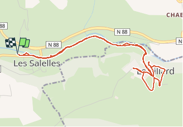

Length
6.5 km

Max alt
694 m

Uphill gradient
105 m
Km-Effort
7.9 km

Min alt
611 m

Downhill gradient
105 m
Boucle
Yes
Creation date :
2020-09-15 13:46:45.522
Updated on :
2020-09-15 15:46:38.834
1h48
Difficulty : Very easy

FREE GPS app for hiking
 SityTrail
IGN / Geographical institutes
SityTrail Plus
The world is yours!
About
Trail Walking of 6.5 km to be discovered at Occitania, Lozère, Les Salelles. This trail is proposed by Lecoester.
Description
départ de l'ai de pique-nique de Les Salleles. chemin tranquille le long du Lot et belle montée vers Le Villard. les remparts sont à voir.
Photos


Positioning
Country:
France
Region :
Occitania
Department/Province :
Lozère
Municipality :
Les Salelles
Location:
Unknown
Start:(Dec)
Start:(UTM)
521958 ; 4925517 (31T) N.
Comments